


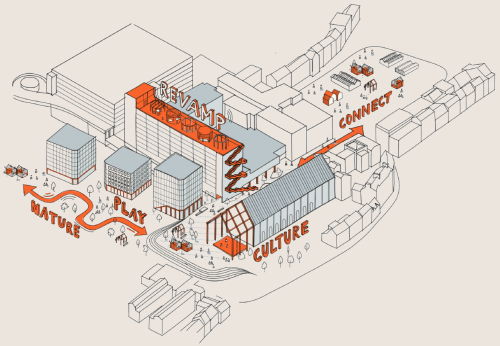
AMPLIFYING GREYFRIARS
Our refreshed vision for Greyfriars!
On this website, we previously shared our emerging vision to transform the Greyfriars area
in Northampton town centre. This was during the first round of engagement, held between
December 2023 and January 2024.
Over 1,500 residents, businesses, community organisations and visitors answered our survey.
This helped us understand your ideas for how we might revamp this part of Northampton's town
centre.
We have listened to your feedback and weaved it into a new iteration of the proposals.
We at West Northamptonshire Council have commissioned the proposals. They have been crafted by
a multi-disciplinary team led by Studio Egret West. This team comprises urban designers,
architects, landscape architects, and transport, commercial and sustainability experts. This
engagement exercise is in partnership with Deetu and will end on Sunday 9th June 2024.
We hope you enjoy looking through the refreshed vision on this website. We invite you to take
a few minutes to complete a short survey at the end to share your views.
This second engagement will complete this stage of the visioning work. Using these plans, we will
seek to secure funding and begin the phased delivery of the site. There will be more opportunities
after this to have your say on our plans. This will be as the project progresses and as we move
into more detailed design of certain elements of the vision.
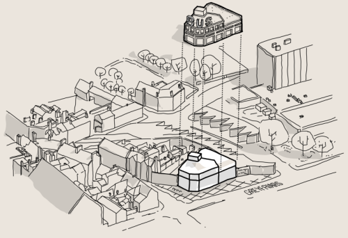
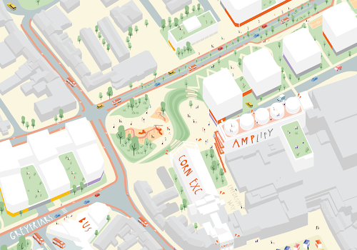
A quick recap of the site and the vision: The vision includes the site of the former
Greyfriars Bus Station, East and West Island, Mayorhold Car Park, Belgrave House, Corn
Exchange, and Victoria Street Car Park.
Click on the map marker to view an aerial photograph of the site today.
Extending the site boundary in response to your feedback: Following the first stage of
engagement, it became clear that we needed to rethink bus operations. Therefore, we extended our
study area to include the site of the Northgate Bus Station. On this website, you will see how we
have responded to comments regarding the Bus Station.
At the end of this website, you will find details about our Amp Northampton public exhibition.
This will be held on Saturday 1st June 2024 in the Grosvenor Centre. We hope to see you there!
Look out for orange highlighted hints like this! They will indicate interactive features on the map.
Map Key
 |
Area of engagement |
 |
Aerial photo of the site today |
What you told us in December 2023
The last time we asked for your feedback, we presented our emerging vision through the lens
of 5 key principles: to amplify nature, creativity, play, living and linkages at Greyfriars.
Your response has highlighted your support for the following key priorities, for Greyfriars
to become:
- a creative hub for the town, that showcases local ingenuity and weaves together culture, performance, craft and youth facilities;
- the home of a new town park in the heart of Northampton, a place to gather, sit and relax in nature;
- a playful space with interactive games areas, play areas for children, outdoor gym spaces for adults, and public art displays;
- a place for intergenerational living that brings together a spectrum of home types and households, including student and later living;
- a neighbourhood that is fully stitched into Northampton, accessible by foot, cycle, and better served by buses, to make it easier to get around the area.
Click on the map markers to read some of the comments we received from the local community. This is just a small selection from the thousands of comments you provided!
You can view the first stage of engagement at
ampnorthampton.com/ideas.The following sections will take you on a tour of Greyfriars. They will show how these themes weave together to form our refreshed vision for the site.
Map Key
|
|
Area of engagement |
 |
Feedback from previous stage of engagement |
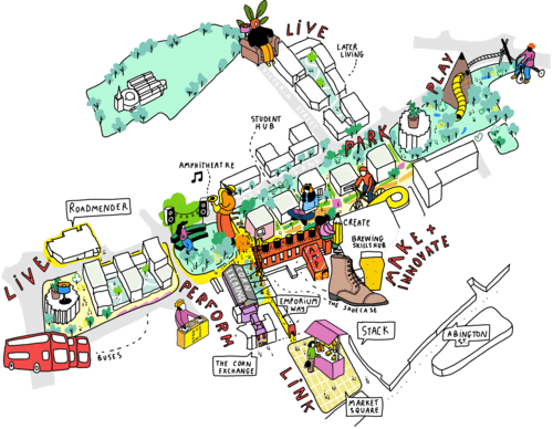
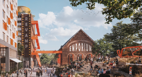
Arriving at Greyfriars... Emporium Way
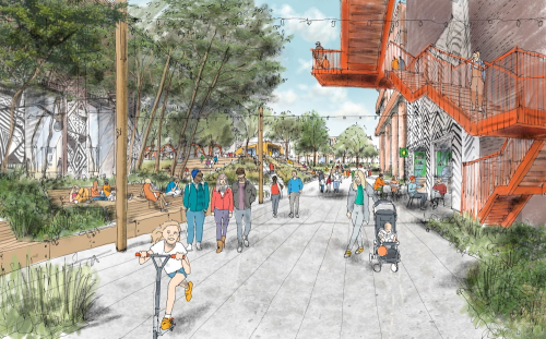
Greyfriars sits forgotten, north of the Market Square, yet barely accessible. Your feedback showed we needed to rethink the arrival experience and the quality of the journey to the site.
Click on the map markers to see a photograph of Emporium Way today, and an artist's sketch of how we could open it up as an exciting new connection to Greyfriars.
Emporium Way is the existing link that runs through the archway on the northern
side of the Market Square. It provides a shortcut to Sheep Street, and Mayorhold
and Newlands Car Parks. It is temporarily closed due to anti-social behaviour.
Our pedestrian-first approach has led us to enhance this connection between the
Market Square and Greyfriars. Many of you have suggested better signage and lighting
to support better pedestrian and cycle access.
Our plan proposes to reopen Emporium Way and craft it into an exciting connection.
Leading into a cultural destination defined by the revamped Belgrave House, Corn
Exchange, and Amphitheatre.
The reinvented Emporium Way will have natural light, new street trees, and places to
sit. We will remove the flyover road section of Greyfriars and the under-utilised
buildings fronting the Market Square. This will transform this dark and isolated passage
into a more welcoming way into the town centre.
Map Key
 |
Our journey through Greyfriars |
 |
Proposed refurbished or new buildings |
 |
Buildings outside of our site boundary |
|
|
Photographs and artist's sketches |
The Amphitheatre
At the end of Emporium way, we arrive at the Greyfriars Amphitheatre. The the West Island, creating a perfect outdoor venue and meeting place. The Amphitheatre could host outdoor performances and serve as a natural lunchtime meeting spot.
Click on the map marker to see an artist's impression of how the Greyfriars Amphitheatre could look.
On the upper level, a sculptural play experience marks the start of Greyfriars Park. This will become a new destination to dwell or play in the town centre, a space that complements the functional role of the Market Square
Map Key
|
|
Our journey through Greyfriars |
|
|
Proposed refurbished or new buildings |
|
|
Buildings outside of our site boundary |
|
|
Artist's impression |
Belgrave House revamped
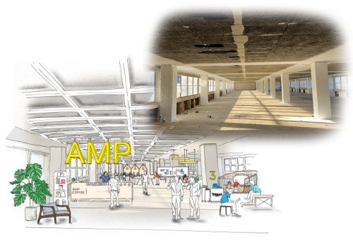
Today, Belgrave House is a vacant building that looms over Greyfriars. We want to revamp the building and transform it into a catalyst for creativity and craft in Northampton, to unlock jobs and opportunities for local people and businesses
Click on the map markers to see a photograph of how Belgrave House looks today, and an artist's sketches of how we could revamp this space.
We are re-imagining Belgrave House as a creative, cultural and community building of many
layers. It will be a co-working hub that celebrates the makers and doers in Northampton.
Belgrave House will provide a unique and flexible space for established and emerging
businesses to grow and showcase what they make. This will differ from the more conventional
commercial and co-working offerings found in Northampton.
The size of Belgrave House will allow for mid-sized enterprises to have a location in the
heart of Northampton. These types of businesses have traditionally been pushed to the edges
of town. Belgrave House will feature hybrid spaces that welcome a blend of manufacturing and
retail uses.
The vision for the building includes:
- A new pedestrian connection from Greyfriars into the ground floor of Belgrave House, and then into the Grosvenor Centre;
- Flexible and affordable workspace for both emerging and established businesses in the town;
- Publicly accessible areas of the building that showcase the products and skills of Northampton;
- A potential location for the HQ of the British Shoe & Boot Institution;
- A colourful external staircase, allowing the public to access the rooftop of the building. This will give impressive views over the town centre and the wider Northamptonshire area;
- Rooftop pods that serve as meeting spaces with outstanding views;
- A refreshed facade, brightening and enhancing the building's silhouette;
- By reusing the shell of the existing building, we can commit to our mission of sustainability and preserve this piece of Greyfriars history.
Map Key
|
|
Our journey through Greyfriars |
 |
Belgrave House |
|
|
Proposed refurbished or new buildings |
|
|
Buildings outside of our site boundary |
|
|
Photographs and artist's sketches |
The Corn Exchange reinvented
It was clear from your survey responses that culture and heritage were important to you. This is why we have continued to imagine a new life for the Corn Exchange.
Click on the map markers to see the artist's sketches of how we could reinvent the Corn Exchange.
This historic building, now abandoned, is a key connection between Greyfriars and the Market Square.
It is a unique piece of architectural heritage. For many years, this hidden gem was a space of leisure
and entertainment. We believe it can become a multi-purpose venue that will celebrate Northampton's
affiliation with art, culture and music.
The Corn Exchange frames the Greyfriars Amphitheatre and gives this new public space a unique character
rooted in the history of Northampton.
The sketches that pop up on the map show a possible re-programming of the Corn Exchange. We imagine that
it could become a culture-led hub that hosts performance and classes. This will complement existing
venues in town, focusing on emerging and education-based arts and culture.
Map Key
|
|
Our journey through Greyfriars |
|
|
The Corn Exchange |
|
|
Proposed refurbished or new buildings |
|
|
Buildings outside of our site boundary |
|
|
Artist's sketches |
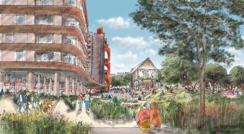
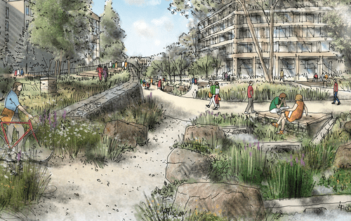
Greyfriars Park and Lady's Lane
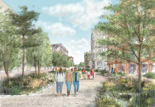
During the first stage of engagement, your support for the creation of a new town park was very encouraging. Northampton deserves a destination town centre park.
Click on the map marker to see an artist's sketch of how Lady's Lane could look.
Today, Lady's Lane is a hostile environment for pedestrians. Our vision for Greyfriars
will create a leafy and green linear park that connects Greyfriars Park and the Greyfriars
Amphitheatre.
The new route will introduce a segregated cycleway and wider pavements. We will achieve
this by reducing the width of the carriageway. This in turn will reduce the negative impact
from fast-moving vehicles. New development nearby will create an attractive frontage
overlooking the space.
Our analysis shows a lack of green spaces within the town centre. This vision will change
that by bringing rich landscaped areas to Greyfriars. These will provide both quiet spaces
and break-out activity zones for table tennis, basketball and other games.
Map Key
|
|
Our journey through Greyfriars |
|
|
Proposed refurbished or new buildings |
|
|
Buildings outside of our site boundary |
|
|
Artist's sketch |
Homes
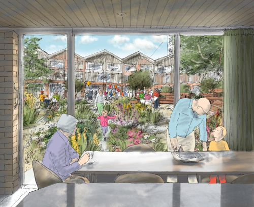
Northampton needs high-quality homes to support its growing population. We know that living
in the town centre is a more sustainable option for many people. For those who wish to live
closer to work, leisure, and public transport.
Greyfriars provides a good opportunity to deliver a mix of homes for a range of households.
We are looking to provide homes to buy, homes to rent, student living and later living in
this location.
We are also looking at more innovative solutions such as cooperative housing. This variety
caters for all, from young professionals to families. It is important to ensure that Greyfriars
welcome an inter-generational housing offer. This means being inclusive for all tenures and
lifestyles.
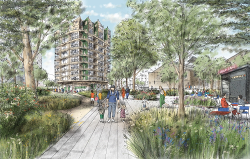
We can strengthen Northampton's role as a university town with attractive and innovative student
living. The site of the former Greyfriars Bus Station is a strong location for purpose-built
student accommodation. It will form an anchor that brings the energy of student life right to
the heart of town.
There are clear links between student living and other aspects of our vision. Such as cultural
uses at the Corn Exchange and flexible spaces for start-ups and enterprises in Belgrave House.
Click on the map marker to see an artist's sketch of how the later living provision could look.
On the site of Victoria Street Car Park, a natural opportunity for Later Living emerges. We
imagine a courtyard that enables communal life and engages with the street and café along Lady's
Lane.
Further west, we would like to introduce a small cooperative living building. This will offer an
opportunity to experiment with a tenure form that is less common in the UK. This means having a
flat in a block where some facilities, such as dining areas and laundry rooms, are shared.
Map Key
|
|
Our journey through Greyfriars |
|
|
Proposed new homes |
|
|
Proposed refurbished or new buildings |
|
|
Buildings outside of our site boundary |
|
|
Artist's sketch |
Optimising and expanding the Bus Station
An important element of feedback from you has been the need to improve bus operations.
In response to your concerns, we have expanded the vision to include the site of the
Northgate Bus Station. Studio Egret West and Civic Engineers have developed a plan to
futureproof the Bus Station.
We understand the importance of the bus network in connecting people to the town centre.
Northgate Bus Station faces a number of challenges due to its limited capacity and
constrained circulation. This is why we have explored options to enhance and expand the
existing facilities. The priority is to ensure the quality, frequency and reliability of
bus services in the town centre, while enhancing user experience and ease of travel.
Click on the map markers to see an artist's sketches of how the existing Northgate bus station could be enhanced and expanded.
We have been working with the town's bus operators and the local community to understand
what makes a great bus service.
Our vision delivers two new elements:
- An expanded provision for buses and layovers, increasing reliability of service.
- New waiting rooms and facilities to improve passenger experience.
We believe there is an opportunity to improve the experience of walking along Sheep Street and re-connect it to the town centre. To achieve this, we would like to create a new building and frontage to the route on under-utilised land. In addition to this we will work to create new crossings and walkable routes from the Bus Station into the Market Square.
Map Key
|
|
Our journey through Greyfriars |
|
|
Proposed Bus Station improvements |
|
|
Proposed refurbished or new buildings |
|
|
Buildings outside of our site boundary |
|
|
Artist's sketches |
Changes to the roads and creating a pedestrian friendly place
Our vision is to reconnect the Greyfriars site and the town centre and overcome the severance
inherited from the 1970s street design, which put cars before people and placed pedestrian routes
underground or in passageways.
We will open Emporium Way and remove the elevated section of Greyfriars Road to create a
pedestrian-friendly public space and uninterrupted route through to the Market Square.
The dotted lines on the map show our vision to restitch the north-south routes, along Sheep Street, Emporium Way and Lady's Lane, and Wellington Street.
Lady's Lane will be transformed into a two-way street with segregated cycle lanes, sustainable urban drainage, wide pavements and active ground floor uses. By removing the one-way system along Greyfriars and Lady's Lane, we will link the East and West Islands. These will be used as public space, introducing green areas for the town centre. Access will be retained to the Grosvenor Centre car park and servicing zones.
Click on the map markers to view an artist's sketches of how sections of these new routes may look.
There will be new signalled crossings at either end of the site. These will be at the Horse Market junction to the west, and the Lower Mounts junction to the east. These will make it easier for people to cross these busy roads and access the new facilities within the scheme.
Map Key
|
|
New north-south routes through Greyfriars |
|
|
Proposed refurbished or new buildings |
|
|
Buildings outside of our site boundary |
|
|
Artist's sketches |
A mix of uses and a vibrant ground level experience
Across Greyfriars, we want to create a range of ground floor uses that open onto the street.
These will complement the cultural uses of our vision and provide amenities for local people.
Uses could include cafés and retail at the bottom of buildings built for homes. It could also
mean canteens and study areas on the ground floor of student living blocks.
The map shows how these ground floor uses could be implemented across the site. Click on
the map markers to view the artist's sketches of this exciting array of amenities.
Map Key
 |
Ground floor creative and perfomance spaces |
 |
Ground floor community uses |
 |
Ground floor mixed use, cafés, retail |
 |
Ground floor living |
 |
Ground floor student uses |
 |
Ground floor bus facilities |
|
|
Buildings outside of our site boundary |
 |
Artist's sketches of ground floor uses |
Nurturing sustainable outcomes, social connection and economic prosperity
Sustainability and community will always be at the heart of what we are doing at Greyfriars.
This means living in a way that protects our natural resources and opportunities for future
generations.
Sustainability has social and economic aspects too. The challenges we face personally and
within our communities fall into these categories. Therefore, acting sustainably can help us
combat the issues we face daily.
We need to take our efforts further to protect our environment and communities. To make West
Northamptonshire a great place to live.
Through our refreshed vision for Greyfriars, we are prioritising:
- preserving and creating habitats and biodiversity,
- improving the quality and integrity of green space and landscape,
- retaining buildings where possible,
- reusing material from any demolitions that may need to occur,
- making efforts to reduce embodied carbon and operational energy,
- and setting an example for how buildings built today can be repurposed and adapted in the future.
We want to create a new healthy and safe neighbourhood at Greyfriars. One that enriches and improves the health and wellbeing of residents and users.
Map Key
|
|
Area of engagement |
 |
Our priorities for Greyfriars |
What's happening next?
Thank you for taking the time to read more about our refreshed vision for revamping Greyfriars. We hope you will join us in amping up Northampton by answering our survey by Sunday 9th June 2024.
Click on the orange button to answer the survey, or click the icon on the map.
question_answer Answer the survey here
Meet us in person!
We are hosting the Amp Northampton public exhibition on Saturday 1st June 2024 between 9AM and 5PM.
This will take place at the Grosvenor Centre in Northampton town centre, in the ground floor mall
space outside Primark. The exhibition will give you the chance to meet the design team and learn more
about our refreshed vision for Greyfriars.
Our exhibition is for everyone and is free to attend - just turn up! We look forward to seeing you there.
Next steps...
This engagement concludes the Greyfriars masterplan and visioning work. Feedback and comments will be
analysed and taken on board. This will inform the next stages where we look at more detailed work on each
element of the masterplan. There will be an opportunity to feed in at later stages. For example, where we
start to dive deeper into how Greyfriars Park might look and feel.
This masterplan will be used to develop a business case for funding. It will be used to speak with funders
such as the Government and Homes England, as well as meetings with developers and investors. Then we can
start to plan on how we want to deliver the proposals for Greyfriars.
Not everything can be delivered at once. The site will need to be split into phases and delivered over a
period of time. We see this as a 5- to 10-year project.
If you would like to find out more about the wider regeneration of Northampton, please get in touch with
the team. You can do this by visiting
or by emailing
regeneration@westnorthants.gov.uk.
Map Key

|
Click to answer our survey |
AMPLIFYING GREYFRIARS
brought to you by:
An
Engaged Space community engagement on behalf of West
Northamptonshire Council.
Powered by
Deetu.
Got a story to tell?
Get in touch.

touch_app Back to the start